In this article
For a lot of our users working in large transportation agencies, data gathering and analysis can be a challenge. Numerous datasets are stored independently from each other, using disparate referencing systems, and shared inconsistently.
One of our customers, the Delaware Department of Transportation (DelDOT), has tackled this problem by relying on Geographic Information Systems (GIS) for data storage and analysis.
DelDOT is a long-time Decision Lens user and they take advantage of the software to manage the development of their Capital Transportation Program, or CTP.
The CTP is a 6-year statewide program with about 120 projects. These include all types of transportation projects; from roadways to transit and bike/ped facilities.
The development is guided by the Council on Transportation and includes a rigorous prioritization process subject to legislative approval. The current process has been in place since 2013, but as the organization matures, they've recently led the effort to make some changes to create a more data-driven process.
As they modify their criteria in a move towards more quantitative performance measures, they require a more streamlined approach to gathering and analyzing data from across the Department and beyond.
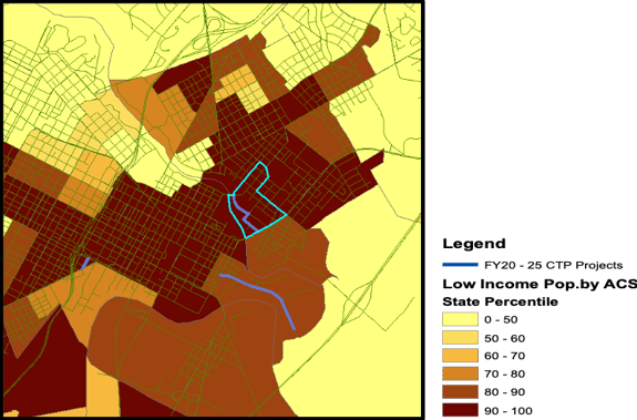
For example, they utilize demographic data published by the EPA to identify vulnerable populations near planned projects. Through proximity analysis, they're able to amalgamate disparate data sources to inform the development of their CTP.
They were able to automate this process with a Python script that allows them to perform this complex analysis easily and repeatedly in a standard fashion.
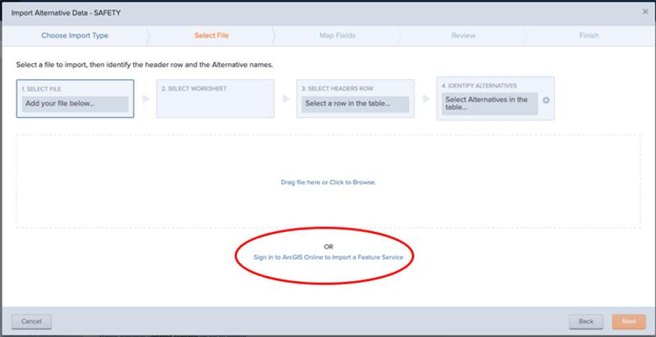
Once they are through with their geospatial analysis, they incorporate it into their decision-making process. Decision Lens can connect directly to your ArcGIS Online account, making it easy to access your content.
If you have used the Decision Lens import wizard before, the process should seem familiar. Instead of uploading a spreadsheet, though, you’ll simply log into your ArcGIS Online instance and select the content you want to bring in.
Once you have completed your work in Decision Lens, you will be able to easily export your results back to ArcGIS Online to communicate with your stakeholders and conduct further spatial analysis.
We have just gotten started developing this new workflow at DelDOT, but we’re hopeful that this streamlined process will help them develop a solid plan that will help them deliver the greatest impact to the state’s transportation system!
To take advantage of the Decision Lens and ArcGIS integration, contact your Account Manager to discuss enabling this feature for your agency.
Want to hear more? Check out our video as we continue this discussion live!